|
|
26 Aerial photos from Italy
from: Aeolic Islands | Apulia | Basilikata | Calabria | Campania | Latium | Southern Tyrol | Tuscany | Umbria | Veneto |

|
|
|
|
|
|
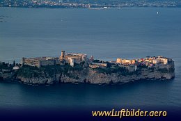
Already in ancient times the harbour of Gaeta was of military importance. The fortress was built in Roman time. The mausoleum of Lucius Munatius Plancus
there stems from the 1st century.
|
|
Picture taken 1.5.2006 -
aerial photo #0007-0570
|
|
|

|
|
|
|
|
|
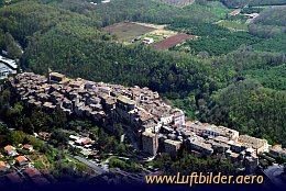
The historical town of Capranica spans over a tuff hill, above of Via Cassia, an old Roman road, that connected Rome and Firenze.
|
|
Picture taken 24.4.2006 -
aerial photo #0007-0044
|
|
|

|
|
|
|
|
|
Here at St. Bernardino Pass commander Hannibal crossed the Alps during the Second Punic War. He marched his army with
55000 warriors and 37 elephants over the 2788m pass.
Today a paved road connects the Rhone Valley in Switzerland with the Aosta Valley in South Tyrol.
|
|
Picture taken 3.9.2005 -
aerial photo #0005-0160
|
|
|
|